Back Vosloorus Afrikaans Vosloorus German Vosloorus English Vosloorus Estonian Vosloorus French Vosloorus NSO Vosloorus Portuguese Vosloorus Siswati Vosloorus Swedish Vosloorus Xhosa
This airticle needs mair soorces fur verification. |
Vosloorus | |
|---|---|
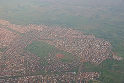
 Aerial view o Vosloorus | |
| Kintra | Sooth Africae |
| Province | Gauteng |
| Municipality | Ekurhuleni |
| Established | 1963 |
| Area | |
| • Total | 32.10 km2 (12.39 sq mi) |
| Population (2011)[1] | |
| • Total | 163,216 |
| • Density | 5,100/km2 (13,000/sq mi) |
| Racial makeup (2011) | |
| • Black African | 99.3% |
| • Coloured | 0.3% |
| • Indian/Asian | 0.2% |
| • White | 0.1% |
| • Other | 0.1% |
| First leids (2011) | |
| • Zulu | 46.8% |
| • Sotho | 18.0% |
| • Xhosa | 8.2% |
| • Northren Sotho | 7.3% |
| • Other | 19.7% |
| Postal code (street) | 1475 |
| PO box | 1486 |
Warning: Page uisin Template:Infobox settlement wi unkent parameter "longEW" (this message is shown only in preview).
Warning: Page uisin Template:Infobox settlement wi unkent parameter "coordinates_type" (this message is shown only in preview).
Warning: Page uisin Template:Infobox settlement wi unkent parameter "latNS" (this message is shown only in preview).
Warning: Page uisin Template:Infobox settlement wi unkent parameter "coordinates_display" (this message is shown only in preview).
Vosloorus is a lairge tounship situatit sooth o Boksburg an juist east o Katlehong in Ekurhuleni Metropolitan municipality, Gauteng, Sooth Africae. It wis established in 1963 when Black Africans wur remuivit frae Stirtonville[2] acause it wis considered bi the govrenment too close tae a white toun. Stirtonville, renamit Reiger Park, haes syne become hame tae Boksburg's coloured commonty.[citation needit] A local authority wis established in 1983 when Vosloorus wis gien full municipal status.[citation needit]
| This Africae-relatit airticle is a stub. Ye can help Wikipaedia bi expandin it. |
- ↑ a b c d "Main Place Vosloorus". Census 2011.
- ↑ Harry Mashabela (1988). Townships of the PWV. South African Institute of Race Relations. p. 169. ISBN 0-86982-343-4.